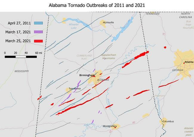
Figure 1: Alabama Tornado Outbreaks

for the 2011 event and CoreLogic Tornado Verification Technology
algorithm for the 2021 events.
It’s the middle of tornado season for the South. A week after a tornado outbreak over portions of the South, a deadly tornado outbreak affected the same region. The Storm Prediction Center issued a high risk for the region and long-track, strong-to-violent tornadoes were expected. The overall conditions for the outbreak on March 25 were more susceptible for severe weather than for the March 17 outbreak: the low-level wind shear, the mid-level wind shear, and the instability were all stronger. This increased instability also resulted in a higher hail risk compared to that of the March 17 outbreak. Despite the weaker surface forcing early during the day (there was no dryline to help focus the storms), there was enough rising motion to cause a few storms. Any storms that did form in this environment had the potential to become supercells, the storms that produce the most tornadoes. The March 17 event may have been compared to the April 27, 2011 tornado outbreak due to its similar location, but March 25 outbreak was more comparable to the 2011 event due to the more conducive conditions for a high-end outbreak than during the March 17 event. The longest tornado path estimated by the CoreLogic Tornado Verification Technology was nearly 100 miles.
Two days after the outbreak in Alabama on March 25, isolated tornadoes were possible with this system as conditions remained susceptible for supercells, but an outbreak of long-track tornadoes was not expected. As the evening of March 27 progressed, several storms extended from Texas to Illinois, including three preliminary EF2 tornadoes in eastern TX extending from Rusk, TX towards Carthage, TX. Even though there were nearly a dozen active tornado regions across Texas, Arkansas, and Tennessee, at any given time during the evening, few of these storms produced tornadoes.
In addition to the tornado threat, flash flooding occurred over portions of Tennessee. This flash flooding occurred from a combination of three events: a large early-morning storm system on March 27th, several isolated supercells that moved over the same region for a few hours during the early-evening, and another larger storm system during the night. Many areas received between 6-8 inches of rain during this period and some areas received more than 10 inches. Nashville recorded its second-wettest two-day rainfall total in history (7.01”) according to the Nashville National Weather Service Office. (Source: National Weather Service Advanced Hydraulic Prediction Service).


